


La Ciotat

Spinnaker
User
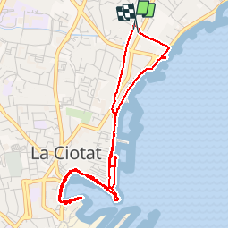

Length
5.3 km

Max alt
15 m

Uphill gradient
42 m
Km-Effort
5.9 km

Min alt
-2 m

Downhill gradient
45 m
Boucle
Yes
Creation date :
2019-10-20 08:26:50.911
Updated on :
2019-10-25 07:29:06.796
1h40
Difficulty : Very easy

FREE GPS app for hiking
 SityTrail
IGN / Geographical institutes
SityTrail Plus
The world is yours!
About
Trail Walking of 5.3 km to be discovered at Provence-Alpes-Côte d'Azur, Bouches-du-Rhône, La Ciotat. This trail is proposed by Spinnaker.
Positioning
Country:
France
Region :
Provence-Alpes-Côte d'Azur
Department/Province :
Bouches-du-Rhône
Municipality :
La Ciotat
Location:
Unknown
Start:(Dec)
Start:(UTM)
712331 ; 4784626 (31T) N.
Comments